Tropics Update: Invest 91L Could Become the First Named Tropical System of the 2024 Season in the Southwest Gulf
Tropics Update: Invest 91L Could Become the First Named Tropical System of the 2024 Season in the Southwest Gulf
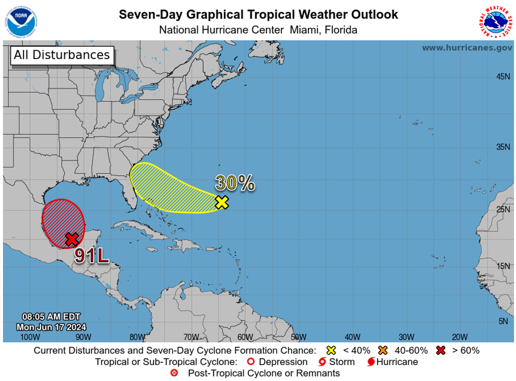
An area of disturbed weather over the southern Gulf of Mexico’s Bay of Campeche, designated as Invest 91L by the National Hurricane Center (NHC) on Monday morning, is likely to develop into the season’s first tropical depression by Wednesday. Moving west to west-northwest at less than 10 miles per hour (mph) toward the northeastern Mexican coast, the system will be investigated by a hurricane hunter aircraft on Monday afternoon.

Invest 91L – Southwestern Gulf of Mexico
- Satellite imagery and surface observations indicate that a broad area of low pressure, now deemed Invest 91L, is forming over the Bay of Campeche.
- Environmental conditions appear conducive for gradual development, and a tropical depression or tropical storm is likely to form by midweek while it moves slowly westward to west-northwestward toward the western Gulf Coast.
- Locally heavy rainfall is also expected to spread over portions of the northwestern Gulf Coast by the middle of this week; an Air Force Reserve Hurricane Hunter aircraft is scheduled to investigate the system later today.
- The National Hurricane Center is outlooking a high (70%) chance of development over the next 48 hours.
- This system poses no direct threat to Florida at this time but will continue to monitored throughout the week.
Southwestern Atlantic Ocean
- An area of cloudiness and thunderstorms, located several hundred miles east of the Bahamas, is associated with an upper-level area of low pressure.
- Environmental conditions could be conducive for some development of this system during the next few days while it moves westward or west-northwestward.
- The system is forecast to approach the coast of the Southeast U.S. on Thursday or Friday.
- This system may bring locally heavy rainfall, gusty winds, instances of coastal/tidal flooding, and hazardous beach conditions to the Florida East Coast later this week, and this system will continue to be monitored.
- The National Hurricane Center is outlooking a low (10%) chance of development over the next 48 hours, and a low (30%) chance of development over the next seven days.
- Computer models are in decent agreement that an area of low pressure could form east of the Bahamas and be steered westward to west-northwestward through mid to late week.
- Consensus suggests that a weaker, more wave-like feature (not a defined center of circulation) will have a more southerly track; a more organized system would likely be steered further northwestward to the Carolinas.
- However, there is uncertainty across the computer models, and it is important to note that computer models struggle when systems do not have a defined center of circulation.
Florida Outlook
- Regardless of development, this system looks to bring increasing rain chances across much of East Florida by mid-to-late week. The Weather Prediction Center is outlooking a Marginal Risk (level 1 of 4) for Flash Flooding across Northeast Florida on Thursday as locally heavy downpours within showers and thunderstorms could bring localized flash flooding for urban and low-lying/poor drainage areas.
- Deteriorating beach and boating conditions can be expected to begin as early as Tuesday; peak wave heights of 5-8’ can be expected for Florida East Coast beaches.
- High Surf Advisories cannot be ruled out later this week for Northeast and East-Central Florida beaches.
- Large ocean swells and breezy onshore winds will also create a high risk for rip currents along the entire Florida East Coast by midweek.
- Minor tidal flooding cannot be ruled out along portions of the Northeast and Space Coasts near and during time of high tide with the upcoming full moon and elevated surf conditions.
- The distant Invest 91L over the southwestern Gulf of Mexico will bring elevated surf and a high risk for rip currents along Panhandle beaches throughout the week.
- Wave heights of 5-9’ can be expected, with breaking waves in the surf zone upwards of 10’ further offshore.
- A High Surf Advisory will go into effect early Tuesday morning and continue through Thursday morning for the far western Panhandle counties (Escambia, Santa Rosa, Okaloosa) due to dangerous beach and boating conditions developing.
- The first name of the 2024 Atlantic hurricane season is Alberto (al-BAIR toe).
The next briefing package will be issued on Tuesday. For the latest information, please visit the National Hurricane Center.
Powered By GrowthZone